 |
Avidyne vs Foreflight waypoint navdata |
Post Reply 
|
| Author | |
chflyer 
Senior Member 
Joined: 24 Jan 2013 Location: LSZK Status: Offline Points: 1056 |
 Post Options Post Options
 Thanks(0) Thanks(0)
 Quote Quote  Reply Reply
 Topic: Avidyne vs Foreflight waypoint navdata Topic: Avidyne vs Foreflight waypoint navdataPosted: 25 Sep 2024 at 2:50pm |
|
The Jepp subscription on my ForeFlight is a device on the same subscription as the IFD navdata.... that is, Jepp data on ForeFlight, IFD100, IFD540 is all under the same subscription/coverage. This coverage is Europe IFR/VFR which includes all the VFR waypoints for Europe. However, it seems that only the charts from the Avidyne subscription map over to ForeFlight. The VFR waypoint navdata is part of the ForeFlight Europe subscription, and is coded differently from the VFR waypoints in the Avidyne.
I am seeing two issues in this regard. Issue 1: The IFD navdata uses VPnnn as the waypoint names for VFR waypoints. ForeFlight uses something different. This causes issues when transferring FPL/Routes between ForeFlight and an IFD and vice versa. Example: If I create an FPL in Foreflight on the Map page, starting in Locarno, Switzerland (LSZL) and then try to route via a couple VFR waypoints, there are two issues when transferring to the IFD. 1) Some VFR waypoints are missing in the IFD navdata. Examples for Locarno LSZL are GORDEVIO and ARBEDO. Both are missing from the Avidyne IFD navdata even though I have the VFR coverage. Both are <10nm from the airport. Although I have VFR waypoints and Intersections turned on under Setup/Map in the IFD, these waypoints are not shown on the map and don't appear under NRST Waypoints. When I transfer the FPL from ForeFlight to the IFD, the IFD creates new FFnnn user waypoints which just clutters up my user waypoints. When creating a route on the IFD it is also necessary to create a user waypoint. 2) For VFR waypoints that exist in both ForeFlight and IFD navdata, they have different name coding. In the Avidyne navdata these have the format VPnnn. That is also shown on the map when turned on. The VFR waypoints in ForeFlight have a different format. For example, Locarno LSZL VFR waypoint E is coded VP010 in the Avidyne navdata and ZLE in the ForeFlight navdata. Similar to case above, when transferring a FPL to the IFD, it doesn't recognize this and creates a user waypoint, even though it has a valid corresponding waypoint VP010. Same in the reverse direction. Question for Avidyne: Is there any plan to coordinate on the VFR waypoint naming with ForeFlight to solve this issue? Issue 2: ForeFlight has some intersections starting with LSnnn for which the Navaid Type is "Named Intersection/RNAV" or simply "Named Intersection". These are not flagged as VFR waypoints nor do they show on ICAO VFR or IFR charts and they don't seem to be official IFR waypoints either. From what I can tell, they appear to have been created along mountain routes which makes routing much easier through mountain valleys and over passes. These do not show on the IFD Map, even if all Intersections and VFR Waypoints are turned on, but they are in the IFD navdata because it recognizes them. They can be entered as intersection names and will be found. They are also properly recognized if included in an FPL/Route received from ForeFlight. They just don't appear on the Map so can't be identified that way for input when adding one "on-the-fly". Question for Avidyne: Is there any plan to add these LSnnn intersections to the IFD Map, since they are already in the navdata? Edited by chflyer - 25 Sep 2024 at 2:55pm |
|
|
Vince
|
|
 |
|
AviSteve 
Admin Group 
Joined: 12 Feb 2018 Location: Melbourne, FL Status: Offline Points: 2326 |
 Post Options Post Options
 Thanks(0) Thanks(0)
 Quote Quote  Reply Reply
 Posted: 28 Sep 2024 at 3:27pm Posted: 28 Sep 2024 at 3:27pm |
|
Question1: The IFD uses the officially published identifiers for all fixes. As you noticed, VFR waypoints are generally identified as "VP" followed by three digits. I looked up GORDEVIO and ARBEDO in the nav database to no avail. If you can send me a screenshot of a chart showing those waypoints, I can check with Jeppesen to determine why they are not included in the database. Using your specific example of waypoint "E" at LSZL, the nav database contains VP010 as the identifier and "E" as the name. I can only assume that Foreflight is synthesizing the identifier ZLE by taking the last two characters of the airport and the "E" part of the name to come up with the name. Avidyne plans to continue using the officially published identifiers as fixes in flight plans. Question2: The "intersections" layer on the IFD map contains those waypoints that are included as part of an airway. Some waypoints marked as "Named Intersection/RNAV" are waypoints along an airway, so you will see those as part of the Intersecitons layer. Often, however, "Named Intersection/RNAV" waypoints are a part of terminal area procedures and, therefore, would not be included in that layer. The nav database contains more fixes identified as "waypoints" than any other kind of fix. So determining which of those fixes to include in the "intersections" layer is tricky. We struck a balance between having enough of them to be useful without overly cluttering the map. It is not in any current plan to change the definition of the intersections layer. But if we were, it is doubtful that we would include any waypoints that exclusively a part of a terminal area procedure. That may cause the waypoint you referenced to still be excluded. |
|
|
Steve Lindsley
Avidyne Engineering |
|
 |
|
chflyer 
Senior Member 
Joined: 24 Jan 2013 Location: LSZK Status: Offline Points: 1056 |
 Post Options Post Options
 Thanks(0) Thanks(0)
 Quote Quote  Reply Reply
 Posted: 29 Sep 2024 at 7:37am Posted: 29 Sep 2024 at 7:37am |
|
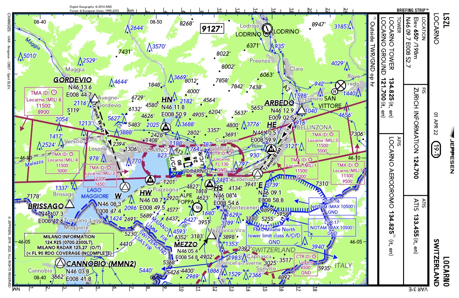
Thanks for the explanation Steve. Here is a screen shot showing GORDEVIO and ARBEDO. I notice that BRISSAGO is also missing, although CANNOBIO is included as VP512.
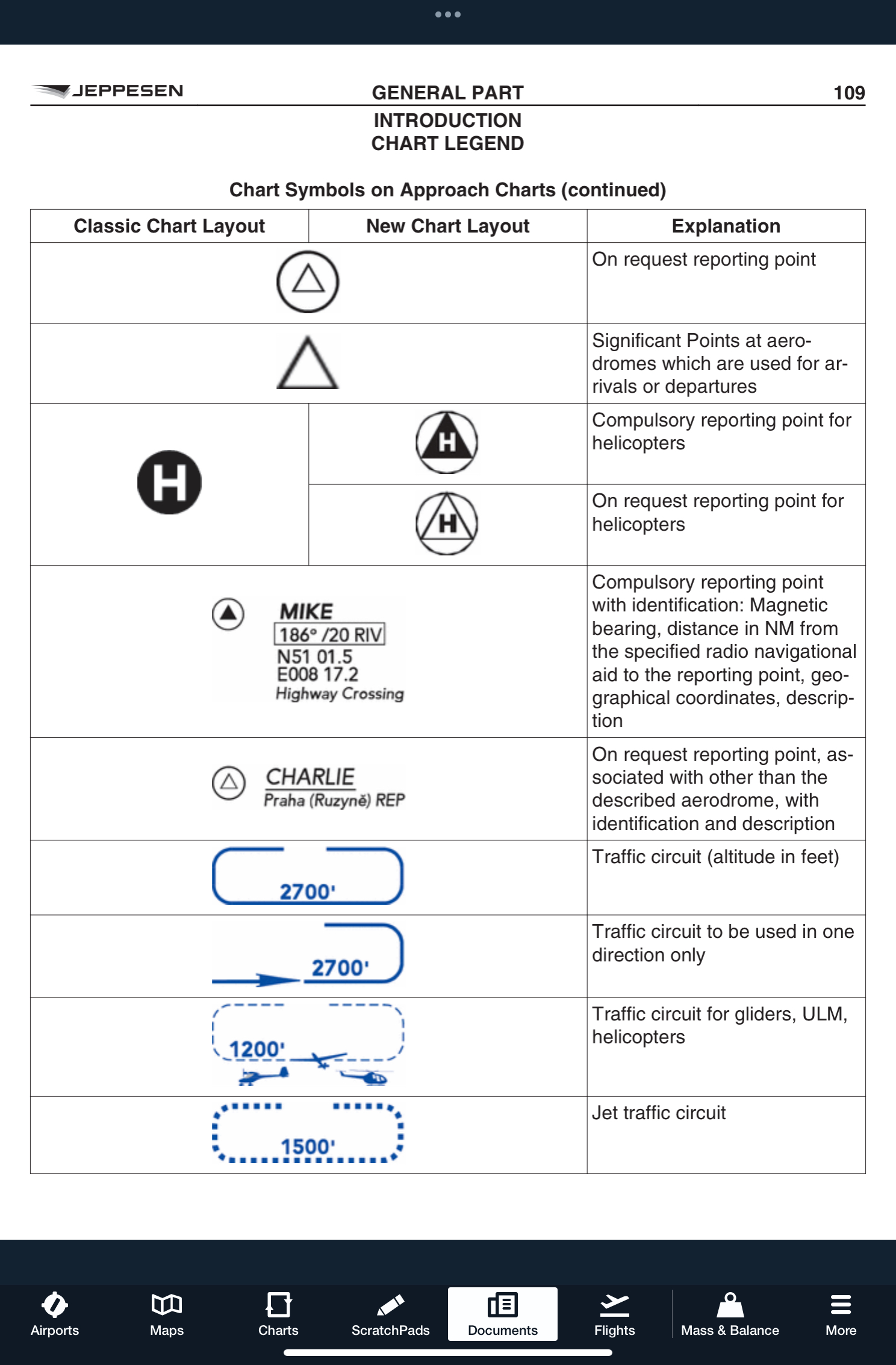
I've also attached a chart legend page from the Jeppesen VFR Airway Manual. These 3 waypoints are shown differently from the others. They are not enclosed in a circle. However, local ATC for the airports expect pilots to know them, and as shown on the map below GORDEVIO is even an end point for a transit route through the airspace. I'll be interested to hear Jeppesen's reason that they are not in the navdata.
  |
|
|
Vince
|
|
 |
|
chflyer 
Senior Member 
Joined: 24 Jan 2013 Location: LSZK Status: Offline Points: 1056 |
 Post Options Post Options
 Thanks(0) Thanks(0)
 Quote Quote  Reply Reply
 Posted: 29 Sep 2024 at 7:58am Posted: 29 Sep 2024 at 7:58am |
|
FYI, I have found the LSnnn waypoints.
These are IFR Enroute waypoints, part of the Swiss Low Flight Network (LFN) which is for rotary wing aircraft able to comply with RNP 0.3. I can understand that you don't show them on the map as I doubt there are or will ever be Avidyne installations in Switzerland for IFR helicopters. As mentioned, they are nice to have for VFR pilots flying through the corresponding mountain routes, but since they are shown in ForeFlight and are recognized if part of an FPL sent to the IFD they can be used as needed that way.
|
|
|
Vince
|
|
 |
|
Post Reply 
|
|
|
Tweet
|
| Forum Jump | Forum Permissions  You cannot post new topics in this forum You cannot reply to topics in this forum You cannot delete your posts in this forum You cannot edit your posts in this forum You cannot create polls in this forum You cannot vote in polls in this forum |