Wishlist for the next IFD software release
Printed From: Avidyne
Category: Avidyne General
Forum Name: IFD 5 Series & IFD 4 Series Touch Screen GPS/NAV/COM
Forum Description: Topics on Avidyne's IFD 5 Series and IFD 4 Series Touch Screen GPS/NAV/COM
URL: http://forums.avidyne.com/forum_posts.asp?TID=334
Printed Date: 03 Jul 2025 at 7:27pm
Software Version: Web Wiz Forums 12.01 - http://www.webwizforums.com
Topic: Wishlist for the next IFD software release
Posted By: TurboPA30
Subject: Wishlist for the next IFD software release
Date Posted: 10 Dec 2013 at 6:07am
|
Want to start this thread to give user input for features missing in the current release: My top 3: 1) Remote TXP support (even if it just the normal Trig/Avidyne that can be remotely controlled, just allows the TXP to be out of immediate reach) 2) MLX770 support. Especially as the touch screen will really make the messaging function useful! 3) Best EX600/5000 integration
|
Replies:
Posted By: chflyer
Date Posted: 10 Dec 2013 at 8:48am
|
And Europe VRP's. An autoroute option when not on airways would also be nice (e.g. when entering a flight plan leg from last wpt to the airport, route via nearest VRP to the direct route). Vince ------------- Vince |
Posted By: tony
Date Posted: 10 Dec 2013 at 9:07am
| Runway extensions, remote controlled transponder, flight plan upload from foreflight, input for ADSB FIS-B data |
Posted By: brou0040
Date Posted: 10 Dec 2013 at 3:37pm
|
I wonder how hard it would be to take the tablet simulator and turn that into an in-flight usable software application, call it the IFD-340. If it already has all the features running the real code, couldn't you just supply live GPS from the tablet to the simulator and essentially have a fully functioning application? Then you can flight plan at home on your IFD-340 and upload that to the 540. Ideally, with the connected panel, you could use the tablet as a semi-dual configuration. I'd love to have a 540-340 connected panel. I understand there are some flight planning features the other software packages have, so there is still a desire to upload flight plans from those applications to the 340/440/540.FIS-B data
|
Posted By: AviJake
Date Posted: 10 Dec 2013 at 3:58pm
|
All good stuff. Maybe this thread can even help influence which of those potential features happen in what order. ------------- Steve Jacobson sjacobson@avidyne.com |
Posted By: oskrypuch
Date Posted: 10 Dec 2013 at 7:22pm
|
The distance to climb/descend arc is a real biggie for me, and I expect a lot of other folks once they see it, and see how powerful and useful it is. Turn that fellow back on! A FIX page, being able to direct the IFD540 to draw on the moving map, user specified circles and radials, relative to given waypoints. For example one could direct the IFD540 to draw a 10nm and 20nm circle, with a radial matching the expected LOC, around your destination. Outstanding for quick orientation. * Orest |
Posted By: Leonard
Date Posted: 10 Dec 2013 at 7:55pm
|
I Really like that 340 option. Can pre-plan ahead of time! I'm with you Orest I was looking forward to those features |
Posted By: tony
Date Posted: 10 Dec 2013 at 8:13pm
| Duplicate post |
Posted By: tony
Date Posted: 10 Dec 2013 at 8:15pm
|
 tony wrote:
Posted By: FORANE
Date Posted: 11 Dec 2013 at 5:04am
Other companies have added this feature through a one time setup of user input data particular to the aircraft they fly. ------------- Lancair 235/320 RV-9A |
Posted By: tony
Date Posted: 11 Dec 2013 at 5:48am
| I stand corrected |
Posted By: oskrypuch
Date Posted: 11 Dec 2013 at 8:45am
Tony, There are two different kinds of predictions. One is predictive based on aircraft performance parameters and supplied wind data, would be used to calculate a full VNAV path, and is typically used in a full FMS to predict a full climb/descent profile. Cool, but probably not practical. The other is just a simple dynamic calculation based on your current rate of climb/descent (with perhaps a bit of buffering), that paints where you will reach the altitude, that is specified in the next defined altitude constraint. That is the Boeing Banana, and works much the same in the Boeings, as I would like to see implemented in the IFD540. It is available in the R9 gear, and from what I understand implementing this in the IFD540 would not be difficult. 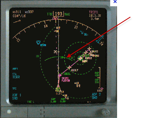 The above is from a 737 MFD, with the 20 deg predictive distance to descent, green arc shown. Incredibly useful for climbs and descents, and even non-precision approaches. It was a great assist to allow for Continuous Descent Approach (CDAP) on a non-precision approach, before all the fancy Integrated Approach Navigation (IAN) modes that are now available. Incidentally, the dashed circular lines you can see on the MFD are pilot configured. Here there is a 25nm & 10nm and a couple more circles drawn around the arrival airport. Outstanding for general orientation on the approach, and would be a feature entirely unique in the GA world. That is the OTHER cool feature I'd like to see in the next release. * Orest |
Posted By: oskrypuch
Date Posted: 11 Dec 2013 at 8:51am
|
GPS, NAV/LOC & HDG mode - hopefully you can get HDG mode past the FAA and into the next release. * Orest |
Posted By: roltman
Date Posted: 11 Dec 2013 at 10:08am
|
HDG mode. |
Posted By: TogaDriver
Date Posted: 11 Dec 2013 at 11:02am
|
FIS-B WX, please. But don't make us buy the TAS600A to do it. you need a GDL39 "like" solution at a decent price-point. Remote Transponder driven by IFD (like the GTN 750 does). A headless Trig TT22 would work admirably. Dynon supports this with their SkyView system.
|
Posted By: Leonard
Date Posted: 11 Dec 2013 at 4:48pm
|
Posted By: FORANE
Date Posted: 11 Dec 2013 at 7:38pm
+2 This is a very useful feature and a tremendous safety boon. I have used it to glide dead stick to runway with reproducible results. Would love to see it in the IFD. ------------- Lancair 235/320 RV-9A |
Posted By: tony
Date Posted: 11 Dec 2013 at 11:25pm
| orest, my experience was the first system you referenced. It was a full blown, DO-236 FMS with VNAV and 4D nav. I remember how difficult it was for getting it to work correctly. I have no experience with the simpler implementation you referenced. |
Posted By: oskrypuch
Date Posted: 22 Dec 2013 at 10:17pm
|
Wish list stuff ... Routes: 1) Can you consider softening the Barber pole (alternating 50% length magenta/ 50% white) depiction of the next leg? To me at a glance it suggests that the Barber pole is the active, not the straight magenta. I might suggest making the next leg depiction Barber pole 90% white and only 10% magenta length stripes. 2) Can you allow wind entry at waypoints, and have it assist ETE calculations? Punching in the forecast wind vectors along the route as an option, at the expected altitudes would be cool. That( might be a bit beyond what you'll do, but I throw it in just for fun. * Orest |
Posted By: AviJake
Date Posted: 23 Dec 2013 at 5:34pm
|
Good stuff. Added to the list of contenders. ------------- Steve Jacobson sjacobson@avidyne.com |
Posted By: brou0040
Date Posted: 05 Mar 2014 at 12:23am
|
I was able to demo unit at the heliexpo last week and was very impressed with it and thankful for the team spending so much time with me going to through the different features. There were two checklist ideas I thought of that I mentioned there but figured I should capture here. First, I think it would be nice to be able to configure checklist triggers. For example, I could create a GAMPS checklist (I have A/C that has to be off for takeoff/landing and fixed gear so my GUMPS is GAMPS) that would trigger within 3 miles of the destination descending through 1000 feet AGL where the range and altitude could be configurable. Ideally I could have a list of and/or triggers where I could use range or time and or altitude and or ground speed etc. This may sound complicated, but you could use a similar interface to the vertical guidance or holding where you say cross 2.0 nm before XYX at or above xxxx 2 min legs and you can configure each of the fields. When you meet the criteria for a triggered checklist, it could give you a pop up warning in the lower right similar to SUA alarts. Second, I didn't find an easy way to reset the checklists inflight without having to uncheck each item. An example would be flying multiple practice approaches. I don't want to clear each checklist item so that I can go through my approach and pre-landing checklists prior to each approach. I don't remember the functionality at this time, but maybe holding the clr button when selecting a checklist when not in the edit mode would clear it and holding the clr at the top level clears all checklists. Either that or any time you go back into a completed checklist, it automatically clears it. |
Posted By: AviJake
Date Posted: 05 Mar 2014 at 8:27am
|
Those are good ideas and candidates for future releases. I already had the 2nd one in that database but the first one is not something we had previously thought about. Thanks for the ideas. ------------- Steve Jacobson sjacobson@avidyne.com |
Posted By: MikeK
Date Posted: 05 Mar 2014 at 4:35pm
|
Since it is apparently not in the initial release: support for the Aspen Connected Pilot. I had assumed that the IFD would have the same degree of support for the Connected Pilot as the Garmin 530 does, since this is a slide-in replacement product. I'm quite unhappy that it does not, as this support was a factor when I chose the IFD over the KSN-770. I am optimistic that this support will be forthcoming. Here are the highest-priority Connected Pilot features that I would want to see:
|
Posted By: oskrypuch
Date Posted: 05 Mar 2014 at 4:59pm
|
Just so you know, I've heard that the latest firmware updates for the 530 from Garmin, break ASPEN's connected pilot. Of course, just a happenstance, eh? * Orest |
Posted By: MikeK
Date Posted: 05 Mar 2014 at 6:29pm
| Ugh. Figures. I hope we don't end up with a situation where the KSN-770 is the only real player in that ecosystem. |
Posted By: Gring
Date Posted: 05 Mar 2014 at 10:29pm
|
Not trying to stir the pot here, but I'm trying to understand why connected panel is so important. For a G430/530 box where flight plan entry is click,click,click it might make life easier. With the IFD, I see flight plan entry as painless, and one that can be done while receiving clearance in real time. Geofill, touchscreen, v-airways. In the NE flight plan routes are almost never what we file, and I bet in a timed test a flight plan can be entered quicker on the IFD than the iPad. Further elsewhere in the country clearance is generally RV or DP then direct, again, just as easy to input in the IFD. I will submit that wireless connection to an iPad to send info to an iPad app like Forflight might be interesting, but not real useful. To be up front, I only use my iPad for flight planning, filing, and charts. I do not use it for navigation, and with the improved moving map and jepp charts on the IFD, I will probably use the iPad only for planning and filing. Tell me why connected panel is so important. |
Posted By: oskrypuch
Date Posted: 06 Mar 2014 at 12:45am
|
Gring's point is well taken. Connected panel makes up for the limited methods of flight plan input in a 530/430, that will be largely a non-issue with the 540. * Orest |
Posted By: Gring
Date Posted: 06 Mar 2014 at 6:41am
| Mike, have you seen the tutorials on the KNS770? The box has way too many different colors and blocks without the uniformity of an integrated interface. Further, to move from function to function way too many button pushes are required. In the case of the 770, connected panel might be a benefit, used to overcome user interface design challenges. |
Posted By: MysticCobra
Date Posted: 06 Mar 2014 at 7:19am
|
I'm not sure I understand what Connected Panel will or won't do, but I'll say this: I've got a panel-mounted GPS and two yoke-mounted devices. When I get a re-route in the air, it does take a little bit of effort and some distraction to keep all three in sync. If there was a universal standard that would allow boxes to share their flight plan data, and I could update one device and push that to the other two, that sure would be neat. Regardless of how easy the data input is, 1x vs. 3x is an improvement.
|
Posted By: oskrypuch
Date Posted: 06 Mar 2014 at 2:08pm
|
Mystic, Depending on the GPS and portable units, you can generally setup crossfill. This not only saves a ton of time, but also will add the approach waypoints into the portable units, normally you will only get FAF inwards if you add a procedure. I have a GNS that crossfills to a 796. The 540 will do the same thing. The flightplan populates onto the EHSI of the ASPEN automatically as well. To me, the benefit of Connected panel might be to overcome the need to enter a flight plan twice, but even more so to make up for the antiquated and non-airway-smart flight plan entry of the GNS units. That will largely disappear as an issue, once the 540 is installed. Perhaps Avidyne will come up with something like Connected Panel, to allow non-panel mount instruments to interface. * Orest |
Posted By: MikeK
Date Posted: 06 Mar 2014 at 5:01pm
|
Orest: Are you sure that the 540 will cross fill to the 796? I thought it had been stated here that it would not cross fill to a 430 or 530, for example, so my assumption had been that it would fill to a second IFD but not to Garmin devices. I can't find that limitation mentioned in the user guide, though, so perhaps I'm mistaken. Gring: I agree that the 770's UI is not up to the standard of the 540. I found it a bit cluttered and hard to interpret, although I think they've made some improvements. I also agree that the 540's method for entering data is vastly superior to the 530's, and probably to the iPad, and you do have a good point about amended clearances for IFR. However, not all flights are IFR, and some flights certainly are cleared as filed. There's a lot to be said for being able to sit inside (perhaps at home) in peace and quiet and plan out the flight, then upload that straight to the panel. It eliminates a potential source for error. With GPS data sent to the iPad, you essentially gain an additional MFD that you can configure as you wish. Perhaps the iPad's screen is more suitable for displaying a chart with the airplane's position depicted, for example, while you use the IFD to look at traffic or terrain. And being able to nominate frequencies from an app on the iPad just makes things that much nicer when you're looking something up in the A/FD, etc. Orest notes that Avidyne may come up with their own Connected Panel-like solution. That's certainly possible, and might even be a good idea. I'd be completely in favor of their doing that if they also support Connected Panel. Otherwise, the problem you may end up with there is a sort of Balkanization, where the Avidyne is able to supply some information over its connectivity, but other devices might still only work on Connected Panel. (JPI is an announced partner for Connected Panel, for example, so you could get up to date fuel information to your flight planning app on the iPad.) So if some devices support Avidyne and others support Connected Panel, then how do you make that work? Switch back and forth between the two? Use one on Wi-Fi and one on Bluetooth? Better to have all the information available through one connection to the iPad. Anyway, Avidyne announced that they would support Connected Panel, and I think that they will. Steve said in another thread that they weren't able to make it work as a drop-in for the 530 for whatever reason, so it was left out of the initial release. I completely understand that and while it's disappointing it's not a show stopper. I just want to make it clear that it's important to me as a customer that they follow through on that support. In closing, I just want to reiterate that I think the IFD has the best interface out there, with the possible exception of the full R9. I flew a G1000 this morning, and I was struck by how much I prefer Avidyne's approach. But I think that there is a lot to offer on the iPad, and being able to smoothly exchange data between the two worlds is a feature that I really look forward to.
|
Posted By: Gring
Date Posted: 06 Mar 2014 at 5:16pm
| Mike, somewhere on this forum is a picture Steve posted of the IFD540 sending info to a Garmin 195/196. Since all the portables use the same Garmin aviation out data format, your portable will be able to display the same way it does today from the 530. Crossfill is something specific between two 530/430 devices and does not use the Garmin aviation data format. |
Posted By: MikeK
Date Posted: 06 Mar 2014 at 6:33pm
| I see, understood. Thanks! |
Posted By: oskrypuch
Date Posted: 07 Mar 2014 at 10:27am
|
Yes, the crossfill on the panel mount devices use a proprietary bus format, no doubt for speed and accuracy. The one-way crossfill to Gx96/95 devices is just RS232, so no issues expected there. As to Connected Panel, it only supports Ipads at the moment, so it is a non-starter for me and many others. It needs support for the now more widely used android devices. CP also requires a 2 unit (PFD+MFD) ASPEN setup, so that reduces the number of candidate installs as well. If Avidyne came up with some sort of direct connection, by wifi preferably, with support for android (and iOS), it could feed all the other panel devices, and would be a better and more general solution. * Orest |
Posted By: GMSutton
Date Posted: 09 Mar 2014 at 1:33pm
|
First, most of us use iPads or some other tablet or handheld device in the cockpit. My T210N checklist is on my iPad, which fits in a yoke mount. The checklist contains sections for each phase of flight, plus emergency procedures and important data such as Va and Vglide speeds at different aircraft weights. That's far more information than could be entered into any panel-mount navigator. Under these circumstances, I have trouble understanding why anyone would want or need to use the IFD540 to run checklists? Second, while Connected Panel is a good idea I suspect it won't last long in practice. That's because it requires an Aspen MFD (won't work with just their PFD) and is already somewhat obsolete. As Orest suggests, Avidyne probably will be better off incorporating some form of wifi connection to handheld and other panel devices. Mike
|
Posted By: MikeK
Date Posted: 09 Mar 2014 at 9:19pm
| I don't see how the Connected Panel could be iPad specific except that they haven't gotten any Android developers on board. But otherwise, it's just Wi-Fi. |
Posted By: 94S
Date Posted: 10 Mar 2014 at 4:48pm
|
I too see a "Connected Panel" type capability as very desireable. I would like to see it as an Avidyne stand alone feature as I don't currently have any Aspen glass (or any glass for that matter) in my panel. It's on the wish list, but many years away. I do have an iPad though. Yes flight plan entry on the IFD's is much simpler than the other stuff, but the more times something has to be entered the more oportunity their is to make a mistake. It would not only be very convenient, but would also reduce the chance for error. I would also really like to be able to rubber band the active leg. The PM page 3-10 "Tips and Techniques" says the active leg cannot be rubber-banded. Out here in the West we have some very long victor airways and even longer direct routes. It would be very useful to be able to rubber-band around wx that pops up on an active leg. David |
Posted By: brou0040
Date Posted: 10 Mar 2014 at 5:17pm
Agree, be able to rubberband the active leg. The IFD should be able to add a current location waypoint and rubberband from there.
|
Posted By: AviJake
Date Posted: 10 Mar 2014 at 7:36pm
|
Yes, I agree about rubber banding the active leg. It is quite involved so we elected to defer that capability to be a candidate for inclusion in a future release. ------------- Steve Jacobson sjacobson@avidyne.com |
Posted By: Awful Charlie
Date Posted: 10 Mar 2014 at 8:11pm
|
Very much support the uploading of flight plans - even by USB is that is quick and easily achievable. It would be especially nice to be able to include altitude changes too! |
Posted By: 94S
Date Posted: 12 Mar 2014 at 4:19pm
| I agree. If it can't be done wirelessly, uploading flight plans byUSB would be better than not. Especially if I could just upload from my iPad with the same USB cable I'd use to power/charge it from the IFD. |
Posted By: PA20Pacer
Date Posted: 14 Apr 2014 at 8:00am
|
This isn't really a "wishlist" item, but a question about an operational procedure that I discovered while using the simulator. I notice that in order to activate the published missed approach, one must go to the FMS page and enable the missed approach after the FAF but before reaching the MAP. For those of us that fly approaches without an autopilot, this is normally a time of fairly high concentration. It could be quite a distraction to leave the MAP page (which shows important information about distance to the missed approach point) for the FMS page, press the LSK to enable the miss, and then return to the MAP page. Is there an alternative for activating the published miss that I am missing? If there is not a good alternative, then such an option would be on my wishlist. Thanks. Regards, Bob ------------- Bob Siegfried, II Brookeridge Airpark (LL22) Downers Grove, IL |
Posted By: TurboPA30
Date Posted: 14 Apr 2014 at 8:15am
|
Actually, when you are over the threshold, a dialog box should pop up: Do you want to go missed? YES (or do nothing for 10 seconds) NO Also, "go missed" should always be a button available after FAF
|
Posted By: brou0040
Date Posted: 14 Apr 2014 at 9:00am
Others think this is important too, there was a short conversation on the "Questions from using the sim" post if you'd like to see the rest of the comments.
|
Posted By: PA20Pacer
Date Posted: 14 Apr 2014 at 10:22am
Thanks for pointing out the other conversation. I had skimmed over it, as it didn't really register before I started playing with the sim. I continue to think that this is an important issue, and I would like to see some capability for enabling the missed approach after the missed approach point, or perhaps a user setup selection to always enable the missed approach. If you are assigned a route other than the published missed approach procedure, I can't see that having the published procedure loaded causes any problems for setting up to fly whatever clearance you are given. Regards, Bob
------------- Bob Siegfried, II Brookeridge Airpark (LL22) Downers Grove, IL |
Posted By: AviJake
Date Posted: 14 Apr 2014 at 3:42pm
|
We agree it would be a great enhancement. ------------- Steve Jacobson sjacobson@avidyne.com |
Posted By: wsh
Date Posted: 14 Apr 2014 at 7:41pm
|
Are the checklist triggerable. . For example the startup checklist (right after start) Taxi Climb Cruise Descent Land? |
Posted By: AviJake
Date Posted: 15 Apr 2014 at 10:59am
|
No, the IFD540 electronic checklists are not automatic upon flight state triggers. You can name and create them any way you want but it's up to you to call them up for display. ------------- Steve Jacobson sjacobson@avidyne.com |
Posted By: Jack Seubert
Date Posted: 26 Jul 2014 at 3:52pm
|
Steve, how about a PBD directly from the Direct To page. It would automatically add the new PBD to the user waypoints in one step. Probably have to add a / key to the keypad. Jack Seubert ------------- Jack Seubert |
Posted By: Awful Charlie
Date Posted: 28 Jul 2014 at 2:15pm
|
1) Given that Jepp are going to be so wild on pricing for Europe charts, can Avidyne make the spec. available for chart data so this can be sourced and added to from elsewhere (even a separate 'user area' for charts if need be) so we can add our own charts/convert the NAA supplied charts for display on the 540. This could also be used to add charts for where Jepp doesn't supply the data anyway. 2) I appreciate the screens are User configurable, but can we have a few configurations to choose from in flight (as on the GNS480), so eg 'Ground', 'Departure', 'Cruise' and 'Approach' where the user data is chosen for that phase of flight 3) In conjuction with the one above, have a few different ''User' sets of saved settings, so that on a shared aircraft each pilot can have their own set of preferences (so the user settings above, north up vs. track up etc) Ben |
Posted By: wsh
Date Posted: 29 Jul 2014 at 2:16am
|
MLXsupport MLX support MLX support And oh yes MLX support Triggerable checklists would be great as well!! |
Posted By: MikeK
Date Posted: 29 Jul 2014 at 4:19pm
|
Well, as long as we're nominating cool features, how about triggerable *audio* checklists? I've had the (extremely nice) experience of flying the jump seat of a Citation X, and was really impressed by how nice the audio checklist is in terms of efficiently running the checklist. The Heads Up unit in the Citation has the audio items recorded into it by Heads Up, it costs to change the checklists, etc. For a unit like the IFD series, I would think a user could record their own checklist audio. Anyway, probably a pipe dream, but can't hurt to mention it. :)
|
Posted By: ddgates
Date Posted: 29 Jul 2014 at 5:02pm
|
That's a good idea. I have also thought about audio emergency check lists, obviously brief, e.g. engine out - change fuel selector, mixture rich, boost pump on, check mags, alternate air - as one example. ------------- David Gates |
Posted By: chflyer
Date Posted: 04 Aug 2014 at 10:48am
|
I'm in the group wishing for transfer of flight plans to the 540. I agree that the 540 is IFR-centric, and FPL entry so much easier than with the Garmin that the feature is not really necessary for that. However, I also fly VFR and I'm not holding my breath waiting for Avidyne to add the hundreds of VRP (VFR Reporting Points) that are associated with VFR approach/departure to/from airports here in Europe, especially since Jepp is involved. I've spent many many many hours just entering these into the Garmin as user WPT in preparation for trips... and need to be careful that they haven't changed since last entered. I have VFR flight planning software (PocketFMS) that includes all these VRP in the db and on the map (and most others do too). It would be really useful if I could transfer flight plans created with this software to the 540. ------------- Vince |
Posted By: Awful Charlie
Date Posted: 07 Oct 2014 at 12:07pm
|
Another one for the list A parallel track function, with user offsets in tenths (or even hundredths) of an NM - for those routes outside controlled airspace where I don't want to be exactly on the same track as anyone else going between two points Another vote for remote transponder control, VFR VRPs, and the ToC/BoD projections, as well as user preferences, charts and flight plan import Ben |
Posted By: Gring
Date Posted: 07 Oct 2014 at 12:22pm
| The IFD has a parallel track function in tenths of a NM in the initial release. I used it over the summer traveling to the Outer Banks where I wanted to be over land, not water. Works great. |
Posted By: oskrypuch
Date Posted: 07 Oct 2014 at 1:37pm
|
1) The Boeing Banana, which will soon be known as the Avidyne Plantain!! (distance to climb/descent restriction, drawn on the screen) 2) A FIX menu function -- custom pilot specified radials and circles, shown on the display, around pilot specified waypoints, * Orest |
Posted By: jhbehrens
Date Posted: 28 Oct 2014 at 2:53pm
|
Ability to add departures to airports in the flight plan other than the airport of origin WX500 strike test Application for editing checklists on a PC (and Mac!)
|
Posted By: FORANE
Date Posted: 28 Oct 2014 at 4:41pm
|
As a purely pie in the sky addition to the wish list, how about this: An emergency mode easily activated which: -immediately places frequency on 121.5 perhaps in standby -provides list of closest airports with arrows showing relative directions and allows for one tap flight plan to selected airport -once airport is selected provides name, frequency, bearing and distance without further button pushing -turns on terrain -draws an arc in front of the flight path based on current altitude, rate of descent, forward speed and surrounding terrain elevation where the arc represents the point of ground impact. ------------- Lancair 235/320 RV-9A |
Posted By: glassanza
Date Posted: 28 Oct 2014 at 8:10pm
|
Would be an incredible feature. I recently experienced a 7k AGL in flight fuel issue that resulted in making an engine out landing; all items listed would have simplified the chaos getting the plane (and myself) safely on the ground. This feature would be a extremely helpful and a great safety marketing tool. ------------- GDC25 |
Posted By: ddgates
Date Posted: 28 Oct 2014 at 8:19pm
Too many features can be as vexing a problem as too few, but I think in what you outlined, it takes a basketful of features and makes them one. Good suggestion. ------------- David Gates |
Posted By: AzAv8r
Date Posted: 28 Oct 2014 at 10:59pm
|
An all-in-one "Oh my gosh I gotta do something" button is a fine idea. Allows one to focus on the aviate and navigate part of being PIC in emergency circumstances. Let me add a candidate sub-feature to the basket: Where a compatible transponder is installed, such as my soon-to-be shiny new AXP340, an option is provided to activate code 7700 in the transponder. A separate button-push to actually activate it, mind you, so one could practice without irritating ATC. Heck, maybe even a button to activate a compatible ELT. Or maybe the same button: "Activate Emergency Transmissions?", which would trigger configured transponder/UAT-out squawks and the ELT. |
Posted By: edanford
Date Posted: 12 Nov 2014 at 10:06am
|
I wish the next way point information block had a Bearing (Brg) to rather than Desired track(Dtr) information. The destination has Brg option, why not next way point? I would like the option to select Brg as single line also ------------- Ed |
Posted By: PA20Pacer
Date Posted: 13 Nov 2014 at 9:16am
|
I would like to suggest that the update rate of the distance information for waypoints viewed using the Nearest feature be increased. I will provide some background behind this request, as there may be a better way of accomplishing my goal. We were navigating on a victor airway that was in the IFD540 flight plan. Ahead of us in the flight plan were several intersections, followed by the next VOR. Due to a radar outage, we were asked to report x miles from that VOR, but the VOR was neither the next waypoint (due to all of the intervening intersections) nor the destination, so the distance to it did not display in one of the datablocks. I tried the Nearest VOR function, which brought up a nice list of VORs, but the distance did not seem to be updating. At that point, I dialed up the desired VOR as a second waypoint in our old Trimble GPS, which has the ability to display information from a second selected waypoint in addition to the next waypoint in the flight plan, but it would be nice to be able to accomplish this task with the 540 only. I tried replicating this scenario in the iPad simulator, and the distances for VORs displayed using the Nearest function seemed to be updated about every 20 seconds, which is a little slow for giving a precise position report. I suggest that the update rate be increased, or perhaps someone can enlighten me about an alternative way to easily display distance information for a waypoint that is not the destination or the next waypoint in the flight plan. Regards, Bob Siegfried, II ------------- Bob Siegfried, II Brookeridge Airpark (LL22) Downers Grove, IL |
Posted By: Gring
Date Posted: 13 Nov 2014 at 9:22am
|
Bob, You can configure a datablock to display the VOR, Distace, Radial to the tuned and identified VOR in the NAV radio. That would have given you the information you requested, updated real time. Another way is to use the range rings on the MFD to estimate distance which should be accurate enough for ATC position reporting (remember time/speed/distance calcuations?). A third way, although not an IFD, could be a two finger tap in Foreflight to measure the distance from your position to the VOR on the sectional.
|
Posted By: brou0040
Date Posted: 15 Nov 2014 at 11:45pm
|
I listed some feature requests in the " http://forums.avidyne.com/forum_posts.asp?TID=360&title=fms-fpl-page-click-reposition-feature-question" rel="nofollow - FMS/FPL page click reposition - feature question " post because I was continuing from a previous conversation. In addition to push/twist capability and north up 240 arc view, it would be nice to be able to "direct to" a map pop-up box. More specifically, I'd like to be able to pan the map around and select airports getting the pop-up boxes, then be able to hit the direct to button from there and have it populate the direct to menu with the pop-up box location. I understand I can rubberband to an airport, but I may be looking at the weather at multiple airports before I find the one I like. I'd like to be able to hit direct to instead of going back to add it to the flight plan or rubberbanding the route. This would also allow me to divert for weather or airspace easier. I could press a point I want to fly to and hit direct to, which would also avoid the issue of modifying the active leg.
|
Posted By: PA20Pacer
Date Posted: 16 Nov 2014 at 9:11am
Hi Geoffrey- Thanks for the reminder about the VOR datablock. That is obviously the best solution for the situation I described, as long as the VOR is transmitting. I have found the feature in the Trimble to display information for an arbitrarily selected waypoint (outside of the flight plan) very useful at times, and it would be nice if the more advanced sets had a similar capability. However, I can see why such a capability may not blend well with the FMS architecture of the newer units. I have been very impressed flying the IFD540 in my Dad's plane. I find it much easier to use than either of the simulators. It is amazing how well those lower right knobs work for entering data. Regards, Bob ------------- Bob Siegfried, II Brookeridge Airpark (LL22) Downers Grove, IL |
Posted By: 94S
Date Posted: 17 Nov 2014 at 9:18am
I also think the Direct-To a popup location on the map would be very useful. It's one thing I've noticed seems to be missing. Once a point has been selected to go direct-to, it would then be nice to have a choice between inserting it in the current flight plan for the case of diverting around weather, or deleting the remainder of the flight plan and replacing it with the direct-to for the case of diverting to an airport for a precautionary/emergency landing. |
Posted By: AviJake
Date Posted: 17 Nov 2014 at 9:24am
|
Agreed. The Direct-To to a map pop up box feature is in the database as a candidate for potential future inclusion. Personally, I really like this one. ------------- Steve Jacobson sjacobson@avidyne.com |
Posted By: oskrypuch
Date Posted: 17 Nov 2014 at 10:09pm
Could you also add an ability to go to the FULL info page on a pop-up item? Also, you could get it from the info page, but being able to quick-load the NAV freq for a VOR from a pop-up page would be nice. * Orest |
Posted By: oskrypuch
Date Posted: 17 Nov 2014 at 10:17pm
Also, is this working as designed? ... with the METAR broken off screen? * Orest |
Posted By: AviJake
Date Posted: 18 Nov 2014 at 7:18am
|
Sort of. You can pan the map on the 540 with your finger to see the entire box. We've deferred the (enormous) effort to always resize the METAR box size for the available real estate since it's so easily pannable. ------------- Steve Jacobson sjacobson@avidyne.com |
Posted By: oskrypuch
Date Posted: 18 Nov 2014 at 11:10am
|
Well, even reducing the font size, or to a narrow font would help a lot. Intelligently formating it would be a bit of work, but even just a line-break for space substitution after so many characters would help. In any case, there are far more important things to work on, but please leave it on the list. * Orest |
Posted By: AviJake
Date Posted: 18 Nov 2014 at 11:14am
|
Yes, it's an existing entry in our issues database. By definition, we must review every deferred item in the list as part of each release, no matter how small or large the release or feature. ------------- Steve Jacobson sjacobson@avidyne.com |
Posted By: teeth6
Date Posted: 29 Nov 2014 at 10:14pm
|
In using the crossing altitude restriction feature BEFORE a waypoint, I notice the IFD places the restriction visually AT the waypoint. ie, When I get a restriction to cross 20 miles before ANGEE at 4K, the IFD places the 4K restriction on the map visually AT ANGEE. THE TOD feature does work correctly but it is visually misleading to see the restriction 20 miles past where it has to happen. Would it be possible in a future release to have the restriction placed where it actually is? |
Posted By: JBAvidyne
Date Posted: 01 Dec 2014 at 11:45am
Avidyne has identified this already and we have the change coming in R10.1. ------------- Jared Butson (jbutson@avidyne.com) |
Posted By: teeth6
Date Posted: 01 Dec 2014 at 11:57am
|
Awesome. Thanks much. |
Posted By: brou0040
Date Posted: 13 Mar 2015 at 5:50pm
|
Now that I've been sort of able to use my 540 (it needs to be RMA'd), there are two things I was finding myself trying to do. Either I couldn't figure out how to do it, or I'd like to request them as feature. I'd like to be able to create a waypoint from the map not rubber banding and not the present position. I think ideal way to do this would be to touch the screen and have an option to be able to create a waypoint at that location. There are a lot of waypoints I'd like to create for mountain passes or weaving through restricted airspace where I'd like to create permanent waypoints, but I don't really know a rad/bearing or lat/long. Also, it would be nice to NOT HAVE fuel on each waypoint datablock. I'd like to know my fuel remaining at my destination long my route, but I don't need to know it at the current waypoint or the next waypoint. That seems to be more fuel information than I need and it takes up screen space. That may not be a big issue with the upcoming ability to scroll datablocks, but I think it would be nice to free up those lines to have more datablocks on the screen at once.
|
Posted By: AviJake
Date Posted: 14 Mar 2015 at 5:49pm
Yup, that's already in the candidate database.
Okay, that's a new one to me but I've just entered it in the database. ------------- Steve Jacobson sjacobson@avidyne.com |
Posted By: brou0040
Date Posted: 10 Apr 2015 at 10:35pm
|
1: When any of the times are less than 1 minute, switch to a second countdown. No sense in seeing 0:00 when you could see 48s. I said 48s so you don't confuse it with 48 minutes although the countdown should make it obvious. 2: When searching for an airport, allow to search by the identifier. I'd rather dial in IYK instead of INYOKERN although I realize it does find it if I type INYO, but it seems like there could be other better examples. I bet there are a lot of Madison's, but only one MSN.
|
Posted By: TogaDriver
Date Posted: 11 Apr 2015 at 11:26am
|
+1 one on going from H:MM to M:SS on the data blocks, but I'd do it when less than 10 minutes (e.g. 9:59). If you go to the FMS page when expanded, you'll note that they actually do this for time remaining to next waypoint in that context. I really miss this on the main page. Putting it in the data blocks would solve this. |
Posted By: brou0040
Date Posted: 11 Apr 2015 at 11:37am
I like your suggesting of switching at 9:59, that gives more time with seconds resolved. I seem to miss the few second countdown timers and having a seconds counter would be much easier to anticipate.
|
Posted By: AviJake
Date Posted: 11 Apr 2015 at 12:12pm
|
Agreed. I thought we did that. Pretty sure we do it on the other products we have. Just entered it into the future feature database. ------------- Steve Jacobson sjacobson@avidyne.com |
Posted By: SB Jim
Date Posted: 15 Apr 2015 at 10:12am
|
One more vote for the ability to enter flight plans from an iPad or Android automatically into the 540 via Wi Fi or Bluetooth. While it's no big deal for short flights longer flights (e.g., west coast to Chicago for example) will take some doing with all the airspace, mountains, etc. that need to be avoided. Plus I've been given extensive reroutes right after take-off essentially redoing my entire filed (and cleared) flight plan. I find the iPad a superior tool for flight planning (hard to beat a large screen in your hands). |
Posted By: chflyer
Date Posted: 15 Apr 2015 at 10:36am
|
+1 and same for user waypoints. ------------- Vince |
Posted By: TogaDriver
Date Posted: 15 Apr 2015 at 10:43am
|
+1 on the WX500 strike test. I didn't know that was even missing. Also, a dedicated screen for traffic and strikes would still be nice but I want to try removing all the LAND and clutter from the Map view to see how close that comes to giving me a similar view. It's probably good enough for now. |
Posted By: oskrypuch
Date Posted: 15 Apr 2015 at 10:52am
Discovered this was missing the other day, you need to add it. * Orest |
Posted By: chflyer
Date Posted: 27 Apr 2015 at 11:29am
|
Here are a couple more features for the wish list: 1) Allow map zoom down to 500' as in Garmin 430. This allows us poor folks without the money for Jepp charts to at least see a/c pos relative to the runways. 2) Include Europe FIS (Flight Information Service) freq under the FSS freq section (although I would tend to consider this a bug rather than a new feature). For example there are 2 FIS in the Swiss (LSAS) FIR: Zurich Info 124.7, Geneva Info 126.35), and many for France: Bale Info 121.25, 135.85, Lyon Info 135.52, 135.20, Seine Info 120.32, 134.30, 118.05, 134.87 all depending on location and altitude, etc, etc. 3) This might be a config issue that I don't know how to fix... but I'm getting CAS warnings (cyan) that are irrelevant for my altitude and tendency (level). As a minimum, CAS warnings should not be issued during level flight when they do not come into play (e.g. level at 4'500 should not give a CAS warning for airspace >6'500). ------------- Vince |
Posted By: SB Jim
Date Posted: 27 Apr 2015 at 1:00pm
|
I'd also like to be able to make the COM sidetone louder. This is normally adjustable on a COM radio. Regards, Jim |
Posted By: Royski
Date Posted: 04 May 2015 at 6:42pm
|
I'd like it to be easier (a) to go direct-to an intermediate waypoint with unit staying in map mode OR (b) center the CDI. Right now this requires four or five user actions to accomplish, assuming you want remain in map mode going to the same waypoint. I use often Direct to re-center the CDI after a deviation while VFR when my exact course doesn't matter, to avoid a pointless excursion back to the old course. Using the direct button requires the expected button presses but further (1) undesirably sequences the FMS to the next waypoint (so that the default direct-to waypoint is no longer the current waypoint but the one after) and (2) undesirably leaves it in FMS/map mode instead of the map mode. I'd rather these didn't happen.
|
Posted By: Leonard
Date Posted: 04 May 2015 at 6:58pm
| +1 Royski |
Posted By: Gring
Date Posted: 04 May 2015 at 7:09pm
| I agree 100% Direct to should not return to the FMS+ page. Lots of extra button pushes and doesn't add any value that I can see. |
Posted By: AviJake
Date Posted: 05 May 2015 at 5:29pm
|
We agree too. So far, we have proven to be lacking enough intelligence to come up with a solution. For reasons I won't explain here, it's way complicated. ------------- Steve Jacobson sjacobson@avidyne.com |
Posted By: cavu
Date Posted: 05 May 2015 at 5:57pm
| The VNAV feature relies on the default descent rate in the AUX section. Would be nice to be able to change that descent rate from the VNAV input on the FMS screen. |
Posted By: Royski
Date Posted: 06 May 2015 at 10:16am
|
Regarding VNAV, it would be nice to be able to not only easily adjust the decent rate as others have suggested, but also to include a datablock showing estimated time to TOD and then advised altitude at the current time. http://forums.avidyne.com/forum_posts.asp?TID=381&KW=&PID=3115&title=requires-baro-input-and-aspen#3115" rel="nofollow - As I've mentioned here before , it's one feature I miss from my KLN-94 GPS. |
Posted By: oskrypuch
Date Posted: 06 May 2015 at 10:23am
More than that, what you really want is to have a TOD "point" as a data block but right in the flight plan strip logically placed where it occurs! This is a common FMS feature. Of course the item would not be editable (or perhaps the planned VSR could be set here), but would list all the other factors, time, distance etc. I requested that some time ago, don't know if it was ever logged as a request. http://forums.avidyne.com/forum_posts.asp?TID=481&PID=6921ᬉ *Orest |
Posted By: ptlevine
Date Posted: 08 May 2015 at 10:56am
|
VSR with a little reminder of what it is referencing: I have VSR as data block on the top of my maps screen. It would be nice to have the VSR show with the identifier it is referencing. When you have a lot of crossing restrictions, it is nice to know exactly what this is keying off such as: VSR (WHITE): -1,200 VSR (KHPN): -800 |
Posted By: Leonard
Date Posted: 08 May 2015 at 2:08pm
+1
|
Posted By: oskrypuch
Date Posted: 08 May 2015 at 10:04pm
|
That is an excellent idea. * Orest |
Posted By: wookie
Date Posted: 10 May 2015 at 11:56am
|
Through all the bizz mumble, don't forget the dedicated traffic page!
Doesn't matter where you are if you run into someone. BH ------------- BH |