Love the 3nm ring on the chart
Printed From: Avidyne
Category: Avidyne General
Forum Name: IFD 5 Series & IFD 4 Series Touch Screen GPS/NAV/COM
Forum Description: Topics on Avidyne's IFD 5 Series and IFD 4 Series Touch Screen GPS/NAV/COM
URL: http://forums.avidyne.com/forum_posts.asp?TID=368
Printed Date: 27 Apr 2024 at 4:05pm
Software Version: Web Wiz Forums 12.01 - http://www.webwizforums.com
Topic: Love the 3nm ring on the chart
Posted By: oskrypuch
Subject: Love the 3nm ring on the chart
Date Posted: 19 Apr 2014 at 10:43pm
|
For orientation, really like the 3nm GREEN ring on the Chart page. Of course, even better would be FIX rings and radials, defined on the FIX PAGE and shown on BOTH the MAP page, and perhaps on the CHART page too ... 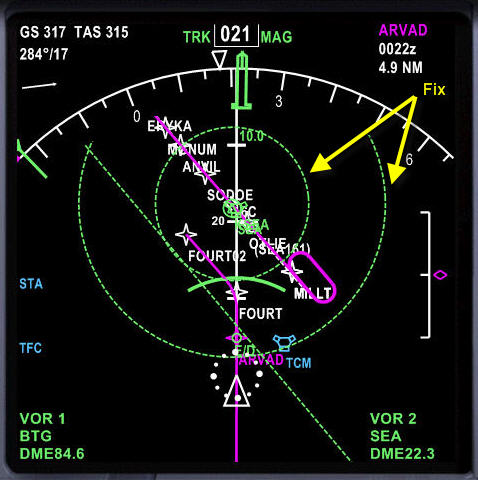 Yes, I know it is on the list already. * Orest |
Replies:
Posted By: Gring
Date Posted: 22 Apr 2014 at 7:06am
| Being a strictly GA guy, if find it fascinating the insight into the tools available on the various part 121 aircraft. On the IFD we have the range rings where the inner ring is 1/2 the distance of the outer ring and can be set by zooming. The function I think you are asking for is range rings irrespective of the zoom level? Not a large difference given the size of the screen real estate. If we had a 12" MFD type display I could see a scenario where the map was zoomed out 100nm and you might want a range ring at say 10 and 20nm for some distance calculation. How do you use the distance rings in the 737? |
Posted By: oskrypuch
Date Posted: 22 Apr 2014 at 9:03am
|
No, these aren't range rings in the same sense. There are range marks on this PFD pic, similar in function to the IFD's, you can see a 20nm mark in white (about mid-screen), and four divisions each marking 10nm, making the outer top white arc 40nm from your ship. These are controlled by a scale knob on the (EFIS) control panel. The FIX marks that I'm mentioning are not relative to your airplane, but relative to any waypoint that you designate! There is a so-called FIX page on the FMS (CDU) to do this. In the pic there are two FIX ranges set, marked with light dashed green circles. Both are centered on KSEA, one to show a 10nm range, and the other 20nm. You can also specify a radial to be drawn in. These markings act like other elements in the display, such as airports, VORs, and will move when the view is scrolled, and will scale as the display scale is changed. In essence you have sketched in additional reference markings on the map. They become part of the map. It is an incredibly powerful feature, as it gives instant orientation to destinations, departures (say for complicated SIDs), intermediate navigation help, marking of range to ETOPS airports, or areas to avoid, and so on. And what is shown on the screen, is up to the pilot. There were originally two FIX pages, there are now six in the latest software on the NGXs. Each FIX page handles one FIX element(s). That can be an airport, nav beacon or any named waypoint. Once a name is filled in, you then specify up to three distance circles to be drawn, and each circle designation can also include a radial to be drawn with it. Setting a 10nm & 20nm circle to your destination airport, with a radial drawn in parallel to the planned runway, is an obvious choice. A FIX page-like feature for the IFD is just a suggested feature, but Steve has put it on the future feature candidate list. BTW, you can also see the range to climb/descend arc (Boeing Banana) shown on the screen, just above the FOURT waypoint, in heavy green about 20* in size. That is where the aircraft will cross its next altitude restriction or altitude preset given its current rate of descent/climb, another amazing feature. This is available on the R9 panels, but didn't make the initial release of the IFD, but hopefully we will see it in the next refresh. With the ability to set altitude restrictions in the IFD for each waypoint (and the auto setting of approach ones), this feature would be a natural! * Orest |
Posted By: Gring
Date Posted: 22 Apr 2014 at 9:12am
| Ahh, got it, distance from a fix rather than a range from the aircraft current position. Makes sense. I like the concept of the Boeing banana, similar to the Top of Descent (TOD) marker in reverse. |