
|
Strange Map Symbols |
Post Reply 
|
| Author | |
MarcDMcD 
Newbie 
Joined: 19 Jan 2018 Location: Central Texas Status: Offline Points: 15 |
 Post Options Post Options
") Thanks(0) Thanks(0)
 Quote Reply Quote Reply
 Topic: Strange Map Symbols Topic: Strange Map SymbolsPosted: 19 Jan 2023 at 11:05pm |
|
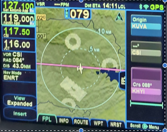
What are these light green colored circles and rectangle on the IFD 540 FMS map? They appeared and then disappeared a few minutes later. I musta been asleep when Avidyne training videos discussed these symbols.
 Edited by AviSteve - 20 Jan 2023 at 11:01am |
|
|
McD
|
|
 |
|
|
AviSteve
Admin Group 

Joined: 12 Feb 2018 Location: Melbourne, FL Status: Offline Points: 2326 |
Post Options
Thanks(0)
Quote Reply
Posted: 20 Jan 2023 at 11:00am |
|
Those are areas around airports where terrain awareness is inhibited. In version 7 of the pilots guide, they are described on page 4-32. In version 8 (the 10.3 version), they're described on page 4-44.
|
|
|
Steve Lindsley
Avidyne Engineering |
|
|
|
|
dmtidler
Senior Member 

Joined: 12 Feb 2016 Location: USA Status: Offline Points: 635 |
Post Options
Thanks(0)
Quote Reply
Posted: 20 Jan 2023 at 11:27am |
Those appear to be the FLTA runway suppression areas around the three paved airports shown in this screenshot. The three private airports have circular FLTA runway suppression areas because their runway directions are not defined in the nav database. The runway at the public 1T7 airport is in the database and that leads to the rectangular FLTA runway suppression area. It appears that the IFD airport filter is being used to not show the actual airports. The IFD airport filter does not appear to filter out FLTA runway suppression areas around airports that are being filtered from display on the IFD map. The FLTA runway suppression areas only display within 10 NM of the aircraft's position and altitudes within approximately 3000' AFE.
|
|
|
|
|
Post Reply
|
|
 Tweet
Tweet
|
| Forum Jump | Forum Permissions You cannot post new topics in this forum You cannot reply to topics in this forum You cannot delete your posts in this forum You cannot edit your posts in this forum You cannot create polls in this forum You cannot vote in polls in this forum |


 Topic Options